|
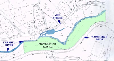
| PROPERTY #11
Far Mill River & Commerce Dr.(1)
Acquired in 1982 - 12.66 Acres Deed Record - Volume Page
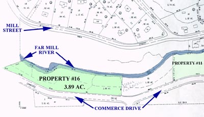
Map #38 Lot 3 | PROPERTY #16
Far Mill River & Commerce Dr.(2)
Acquired in 1986 - 3.89 Acres Deed Record - Volume Page
Map #38 Lot 2 | Property List || SLT Home
Maps Property #11
 Property #16
Description Property #11 A certain piece or parcel of land, situated in the City of Shelton, County of Fairfield, and State of Connecticut bounded and described as follows: Beginning at a point which is the southeast corner of property designated as open space on map entitled Subdivision Plan, Shelton Research Park, Section Two by J. D. Kasper Associates dated January 24, 1978; said point being located on the north Right of Way line of Commerce Drive; thence proceeding northerly 235.99 feet along said open space parcel also being the limit of the Shelton REsearch Park, Section Two subdivision to the approximate centgerline of the Far Mill River; thence proceeding easterly 2612.74 feet along the approximate centerline of the Far Mill River to property now or formerly of Josepy and Lydia Menustik; thence proceeding southerly, westerly, and southerly 365.38 feet along property now or formerly of Joseph and Lydia Menustik to a point which is the southwest dorner of property now or formerly of Joseph and Lydia Menustik; thence proceeding easterly along property now or formerly of Joseph and Lydia Menustik to a monument marking the point of tangent of a curve on the north Right of Way line of Commerce Drive; thence proceeding westerly along the north Right of Way line of Commerce Drive to the point of beginning. Property #16
Property List || SLT Home |