|
PROPERTY #5
End of Thoreau
Acquired in 1978 - 3.07 Acres
Deed Record - Volume 364 Page 304
Map #181 Lot 44 Property List || SLT Home
Map 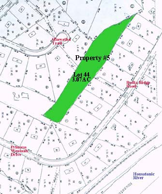
Description A certain parcel of land commencing at a point, said point being the Southeast corner of Lot #1 on map entitled, “Record Subdivision Map of Rodia Ridge Estates, Section 5, Shelton, Conn., Scale 1” = 100’ — March 12, 1975 — Last Revised May 22, 1977; thence proceeding S35°—32’—43”W a distance of 54.6’ to a point; thence proceeding S41°—44’—07”W a distance of 92.26’ to an iron pipe; thence proceeding N25°—55’—35”W a distance of 153.11’; thence proceeding N46°—06’—34”W a distance of 589.85’ to the Northwest corner of Lot #32, Rodia Ridge. Section II; thence proceeding N34°—50’—18”W a distance of 85.72’; thence proceeding N31°—50’—53”W a distance of 49.13’; thence N15°—59—43”W a distance of 86.85’; thence N4°—55’ 53”W a distance of 25.91’; thence N15°—37’—08”W a distance of 34.98’; thence N19°—28’—23”W a distance of 139.61’ to the Southwesterly corner of Lot #7 on map of Rodia Ridge, Section 5; thence proceeding S44°—16’—00”E a distance of 149.91’; thence S42°—49’— 14”E a distance of 152.79’; thence S48°—29’—58”E a distance of 151.45’; thence S41°— 51’—55”E a distance of 150.74’; thence S37°—44’—53”E a distance of 151.48’; thence S38°—54’—l8”E a distance of 151.92’; thence S44°—l4’—26”E a distance of 199.61’ to the point and place of commencement. Said parcel contains an area of 3.07 Acres ±. For a more detailed description of property, reference is hereby made to a map entitled, “Record Subdivision Map Section V, Rodia Ridge Estates — Shelton, Conn. Scale 1”=l00’ — March 12, 1975, Last Revised May 22, 1977, made by Joseph Wysowski, Registered Land Surveyor.
Property List || SLT Home |